I noticed that the Hamilton County Park District has posted information for this year's hiking staff program. If you are not familiar with it, the hiking staff program is a neat program where you can hike 7 Hamilton county park trails within the course of a year and then qualify for a hiking staff or emblem. It is a neat little challenge and a great way to introduce younger family members to some of the great park trails in the county. Many of the trails are under a mile in length all the way up to the 7.8 mile outer loop of the Shaker Trace Trail at Miami Whitewater Forest.
The link to an Adobe PDF file that can be printed out is at:
http://www.hamiltoncountyparks.org/rec_trails/Hiking_Staff_Record_2008.pdf
You will need a copy of the free Adobe Reader to view this file. It contains more information on the program, and a list of trails and the parks they are located in. The hiking staffs are only $3.00, and then you can purchase emblems for $2.00 for each following year you complete the program.
It is pretty simple to complete 7 trails within a year, and there are probably a few who could easily do it in a single day. I think it is a fun way to introduce kids to the fun of hiking, and they should get a kick out of working toward their very own hiking staff. I completed this for the first time last year with my three daughters, and plan to do it again this year. I will be sure to add my trip reports and photos as each trail is completed.
Thursday, February 21, 2008
Sunday, February 17, 2008
McFarland Woods Mt. Airy Forest 2/16/2008

It was a beautiful day for a hike. The temperature was in the 40s, the sun was shining, and there was no wind. The trail in McFarland Woods in Mt. Airy Forest (Cincinnati, OH) had a lot of ice on the path. It was funny, since the ice seemed to cover the trail and not much else. It made for some slick hiking, but my Rocky boots really had good grip. I carried a small fanny pack with 1L of water in two bottles, some energy bars (that I did not need) and a few other items.
I might switch to a small daypack, since I always have a hard time putting the water bottles back into the fanny pack water bottle holders. It is an Outdoor Research fanny pack from Walmart. It was cheap and does the job, but it is too much effort returning the water bottles after a drink. With a light daypack, I could use my Camelback on the warmer days when I do not need to worry about the tube freezing.
I went on this hike with the Tri State Hiking Club, and about 40 to 50 people showed up for the hike. It took some getting used to the ice at first, but I gained more confidence and slipped only once. We followed much of a trail that was marked as the "E" trail. We did not follow it completely, since we were trying to stick to about a 4 mile loop. It had a few ups and downs, but was in no way as strenuous as the Fort Hill Hike in Highland County last month.
We completed about a 4 mile loop in an hour and 45 minutes. We held up a few times to wait for some of the slower hikers. This was fine, since it was a beautiful day and it was nice meeting some members of the club I had not had a chance to talk with before.
I did not take the time to download a map like I usually do. When I hike in a new area I have not been to before, I like to get an idea of the trail length, terrain, etc. A good source for maps of the area is at the City of Cincinnati website at:
If the link does not appear, copy and paste the following to your web browser:
http://www.cincinnati-oh.gov/cityparks/pages/-3066-/
If you click on the maps link at the city's website after clicking the link above, you will see another page with a link called "Trail Map #1". This is the best map I have found yet of the area. If anyone else has a link to a better one, please feel free to share it with me and anyone else who might read this blog.
Here is a link that should take you directly to a view of the map:
If the link does not appear, copy and paste the following to your web browser:
http://dynamic.cinci-parks.org/images/park_media/326.jpg?55
Saturday, February 16, 2008
Fort Hill Hike 1/20/2008

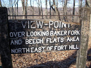
Overlook point near the earthworks.

Looking down at one of the rock formations.

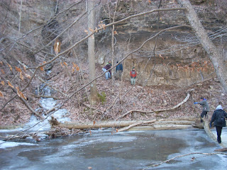
The fisrt stream crossing. Check out the tunnel on the other side!
This was a challenging hike for me. I grew up in one of the flattest areas of Ohio (the Till Plain of Northwest Ohio). The Fort Hill Nature Preserve has a challenging climb of over 400 ft up a decnt switchback trail to the top of the old Indian ruins.
I went with the Tri State Hiking Club, and we had a group of about 20 people or so. It was nice to be able to hike with a group to have the extra support.
We started out on the trail about 1:00 PM, and the temperature was probably around 15 degrees Fahrenheit. It was very cold. I actually got a little warm toward the end of the hike from all of the heat I was generating from hiking.
I had never been to this trail before, and I was under the impression that when we had completed the first big 400+ foot climb, the hard part was over. I was mistaken.
We had to make several other climbs, and the trail had many ups and downs. The temperature made it a little dificult for me. I almost felt like I was having cold weather induced asthma. It felt like I was hiking with half of one lung most of the time. It was hard to catch my breath a few times.
We had to make a couple of crossings of the main creek that runs through the area. I beleive it is called Baker Creek. There were logs across the stream for both crossings, but the water was still flowing and higher than the tops of my Rocky boots that I was wearing. I had spare socks in my backpack, but I did not want to test how waterproof my boots were in 15 degree weather.
The first crossing was the easier of the two. It was right before an area where there is a rock tunnel on the other side. I stuck my Lekis into the cold water and slowly walked across the log to make it to the other side.
The second crossing came much later in the hike when I was tired, out of air, and a little dizzy and dehydrated. My tube had frozen long ago on my Camelback. I had to take it out of my ULA Conduit pack and unscrew the lid to drink right from the bladder. I emptied it out before the second stream crossing. The log was high in the air and required walking across it without the aid of my Lekis in the water. I was so dizzy, I decided to scoot across the log on my rear. This was tough, since my fleece pants did not want to slide along the log. I made it across with a lessened sense of pride, but I stayed dry.
When we got to the end of the loop to the parking area, I would guess that we had hiked 7 or 8 miles. I really do not know the exact distance. Much of the trail we followed was part of the Buckeye Trail, and it was well blazed.
One of the neatest parts of the trail was the restored log cabin that we walked through. The Gorge Trail goes right through the cabin!
I think we finished up around 5:00 or 5:30 PM. Fortunately we made it back before it got dark. Overall, it was a good workout and made me realize that I need to hike some more hills and get used to that type of hiking. I hiked about 50 miles of the Buckeye Trail last year, but it was mostly flat. My legs are not used to climbing.
We ate at the Ponderosa in Hillsboro. I had the dinner buffet. It was not all that great, but I was so hungry, tired and thirsty I did not care. The Tri State Hiking Club is a great group, and I look forward to going on a lot more hikes with the group in the future.
Subscribe to:
Comments (Atom)


